
Burlington Climatology
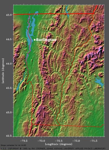
Burlington, Vermont is located on the eastern shore of Lake Champlain with the Adirondack Mountains to the west and the foothills of the Green Mountains to the east and southeast, as can be seen on the topography map below. The Local Climate Data indicates that the Burlington International Airport lies at an elevation of 330 feet.

The topographical map of Vermont shows that Burlington is located on the eastern shore of Lake Champlain with the Adirondack Mountains to the west and the Green Mountains to the east. (Courtesy of Johns Hopkins University.)
The climate of Burlington is that of a typical New England climate, however, Lake Champlain has a modifying effect on the severity of the rapid changes in weather. Lake Champlain also has a modifying influence on temperature prior to the lake freezing which causes winter temperatures along the lake shore to often be warmer than temperatures at the Burlington International Airport. The coldest temperatures during the winter months are produced by rapidly moving high pressure systems coming from central Canada or the Hudson Bay, but it is rare for very cold temperatures to persist for an extended period.
Burlington receives less precipitation than other parts of the state due to the shielding effects of the Adirondack and Green Mountains to the west and east. However, during the winter months, Burlington can receive lake effect and lake enhanced snow as a result of Lake Champlain. The city is also located in the path of the St. Lawrence Valley storm track which, with the help of the effects of Lake Champlain, causes Burlington to be one of the cloudiest cities in the United States.
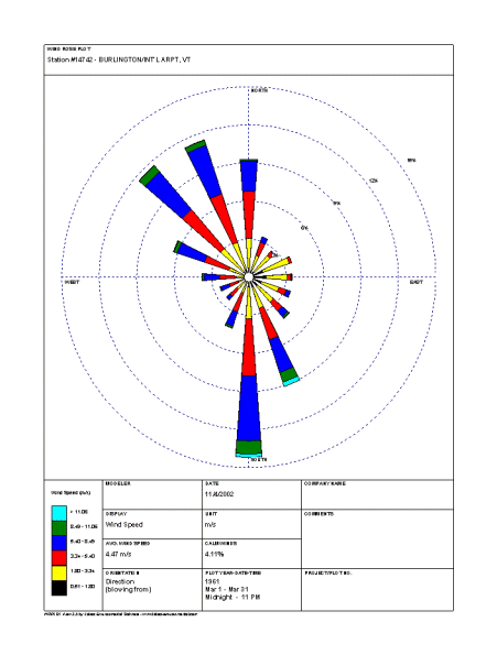
According to the March wind rose for Burlington, the most frequently observed wind direction is southerly and occurs approximately 14% of the time. Winds out of the northwest and north-northwest are also common and occur about 12% of the time, while northerly and south-southeasterly winds occur 9% of the time, and west-northwesterly winds occur 6% of the time. The Adirondack and Green Mountains have an impact on the wind direction at Burlington and cause the winds to usually have either a northerly or southerly component.

The March wind rose for the Burlington International Airport shows that the most frequently observed wind direction is southerly. (Courtesy of the National Water and Climate Center.)
Wind speeds between 3.34 m/s (6.5 knots) and 5.4 m/s (10.5 knots) occur approximately 5% of the time throughout March, while wind speeds between 5.4 m/s (10.5 knots) and 8.49 m/s (16.5 knots) also occur 5% of the time during the month. The Local Climate Data indicates that the maximum observed 2-minute wind speed for March is 33 mph (29 knots).
According to the Daily Almanacs for the first forecasting week (March 9th, March 10th, March 11th, and March 12th), the normal daily high temperature for March 9th, 10th, and 11th is 37°F and the normal daily high temperature for March 12th is 38°F. The record high temperatures for these days are, chronologically, 66°F, 63°F, 56°F, and 62°F, and the record lowest maximum temperatures are, chronologically, 10°F, 13°F, 16°F, and 8°F.
The normal daily low temperature for March 9th and 10th is 19°F and the normal daily low temperature for March 11th and 12th is 20°F. For this period, the record low temperatures are, chronologically, -15°F, -9°F, -8°F, and -14°F, and the record highest minimum temperatures are, chronologically, 48°F, 44°F, 40°F, and 39°F.
The average daily precipitation for March 9th, 10th, 11th, and 12th is consistently 0.07 inches and the record daily precipitation is, chronologically, 0.72 inches, 1.20 inches, 0.87 inches, and 1.20 inches.
For the second forecasting week (March 16th, March 17th, March 18th, and March 19th), the normal daily high temperature for March 16th, 17th, and 18th is 40°F and the normal daily high temperature for March 19th is 41°F. The record high temperatures are, chronologically, 78°F, 69°F, 62°F, and 58°F, and the record lowest maximum temperatures are, chronologically, 19°F, 11°F, 10°F, and 19°F.
The normal daily low temperature for March 16th and 17th is 22°F and the normal daily low temperature for March 18th and 19th is 23°F. For this period, the record low temperatures are, chronologically, -9°F, -4°F, -7°F, and -10°F, and the record highest minimum temperatures for these days are, chronologically, 41°F, 49°F, 45°F, and 44°F.
The average daily precipitation for March 16th is 0.07 inches and for March 17th, 18th, and 19th is 0.08 inches, and the record daily precipitation is, chronologically, 0.45 inches, 0.93 inches, 0.65 inches, and 0.73 inches.


