
Seattle Climatology
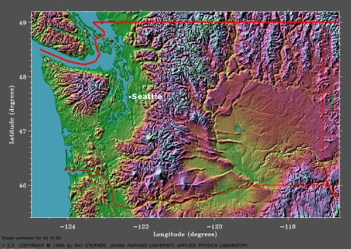
Seattle, Washington is situated between the Puget Sound and the Green River Valley, with the Puget Sound located to the west of the city and the Green River Valley to the east. According to the Local Climate Data, the Seattle-Tacoma International Airport lies at an elevation of 370 feet. The topographical map of Washington shows that the Olympic Mountains are located to the northwest of Seattle, with the foothills of the Cascade Range to the east, and the Pacific Ocean to the west.

The topographical map of Washington shows that Seattle is located between the Puget Sound and Green River Valley, with the Cascade Range to the east and the Olympic Mountains to the northwest. (Courtesy of Johns Hopkins University.)
The Cascade Range and the Olympic Mountains have a modifying effect on Seattle’s mild climate. In particular, the Cascade Range shields Seattle from the cold, dry continental air during the winter. Occasionally, pressure distributions can force the continental air into the Puget Sound area, which can result in extreme temperatures for Seattle. Any extreme temperatures that do occur are usually short-lived. The winter months in Seattle tend to have considerable cloudiness and are often rainy, with more than 75% of Seattle’s yearly precipitation falling throughout the winter wet season. With Seattle’s mild climate, snow during the winter is very erratic. Winter storms can produce snow (most often they do not) if they are able to bring in cold Canadian air along with them; however, any snow that does fall usually melts before measurably accumulating.
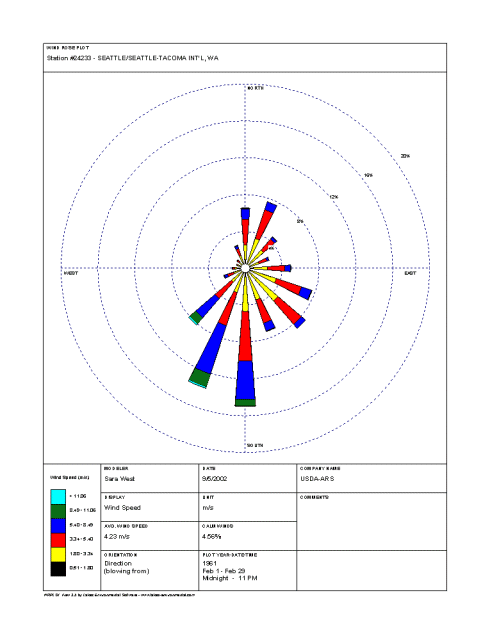
According to the February wind rose for the Seattle-Tacoma International Airport, southerly is the most frequently observed wind direction for the month and occurs approximately 15% of the time. South-southwesterly winds are also common and occur just over 13% of the time, while winds out of the southwest, southeast, east-southeast, and northeast occur about 8% of the time throughout the month of February. Southwesterly winds help to keep Seattle’s average winter temperatures in the 40's°F during the day and in the 30's°F during the night.

The wind rose for the Seattle-Tacoma International Airport shows that the most frequently observed wind direction for the month of February is southerly. (Courtesy of the National Water and Climate Center.)
Wind speeds between 3.34 m/s (6.5 knots) and 5.4 m/s (10.5 knots) occur approximately 5% of the time during February, and wind speeds between 5.4 m/s (6.5 knots) and 8.49 m/s (16.5 knots) also occur about 5% of the time. The Local Climate Data for Seattle indicates that the maximum observed 2-minute wind speed for February is 39 mph (34 knots).
According to the Daily Almanacs for the first forecasting week (February 9th, February 10th, February 11th, and February 12th), the normal daily high temperature for this period is 49°F. The record high temperatures are, chronologically, 62°F, 65°F, 62°F, and 66°F, and the record lowest maximum temperatures are, chronologically, 38°F, 38°F, 37°F, and 32°F.
For this same week, the normal daily low temperature is 37°F and the record low temperatures are, chronologically, 26°F, 24°F, 23°F, and 21°F. The highest minimum temperatures on record for this period are, chronologically, 49°F, 48°F, 47°F, and 49°F.
The average daily precipitation for February 9th, 10th, 11th, and 12th is consistently 0.15 inches and the record daily precipitation is, chronologically, 2.98 inches, 0.96 inches, 0.81 inches, and 1.23 inches.
The Daily Almanacs for the second forecasting week (February 16th, February 17th, February 18th, and February 19th) indicate that the normal daily high temperature for this period is 50°F. The record high temperatures are, chronologically, 58°F, 58°F, 62°F, and 67°F, while the record lowest maximum temperatures are, chronologically, 25°F, 32°F, 38°F, and 33°F.
The normal daily low temperature for this week is 37°F and the record low temperatures are, chronologically, 13°F, 23°F, 20°F, and 22°F. The record highest minimum temperatures for this period are, chronologically, 49°F, 48°F, 50°F, and 53°F.
The average daily precipitation for February 16th, 17th, 18th, and 19th is consistently 0.15 inches and the record daily precipitation is, chronologically, 1.83 inches, 0.65 inches, 1.63 inches, and 1.76 inches.


