


Mesoscale Details
As I pointed out in the previous section, southerly winds were pulling in moisture from the Gulf of Mexico over the state of Missouri. The effect of this can be seen on the 21Z moisture convergence map, which is a combined measure of mass convergence and moisture advection. Wherever there is a pooling of significant moisture, especially along a boundary, it is a good place to look for the potential of thunderstorm development. The southerly winds transporting in moisture would provide ample moisture advection. The 21Z moisture convergence map indicates an area of significant moisture in Missouri along and just ahead of the approaching cold front. With moisture building along the cold front, this boundary would serve as the initiating boundary for the development of strong thunderstorms.
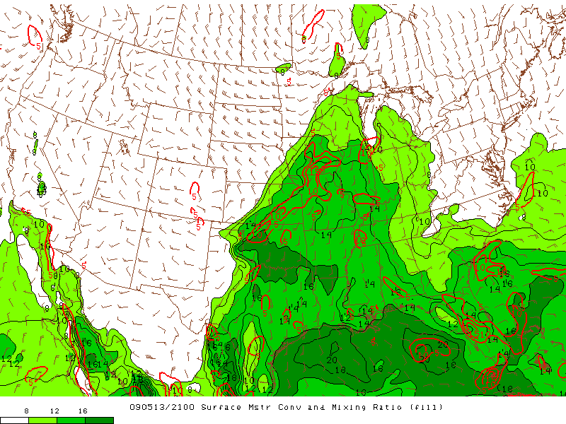
The 21Z moisture convergence map shows an area of moisture pooling along and just ahead of the approaching cold front in Missouri. (Courtesy of the Storm Prediction Center.)
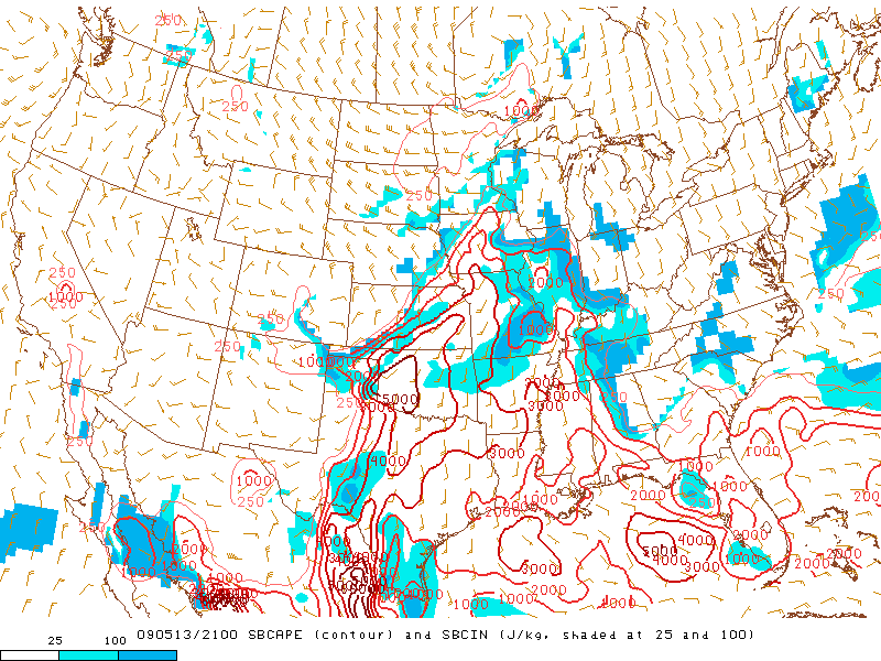
However, in order for strong thunderstorms to develop, air parcels first need to be able to reach the Level of Free Convection. Once air parcels are able to reach their LFC, providing they are able to overcome any Convection Inhibition that may be present, there also needs to be sufficient Convective Available Potential Energy in order for strong updrafts to form which are crucial for thunderstorm development.
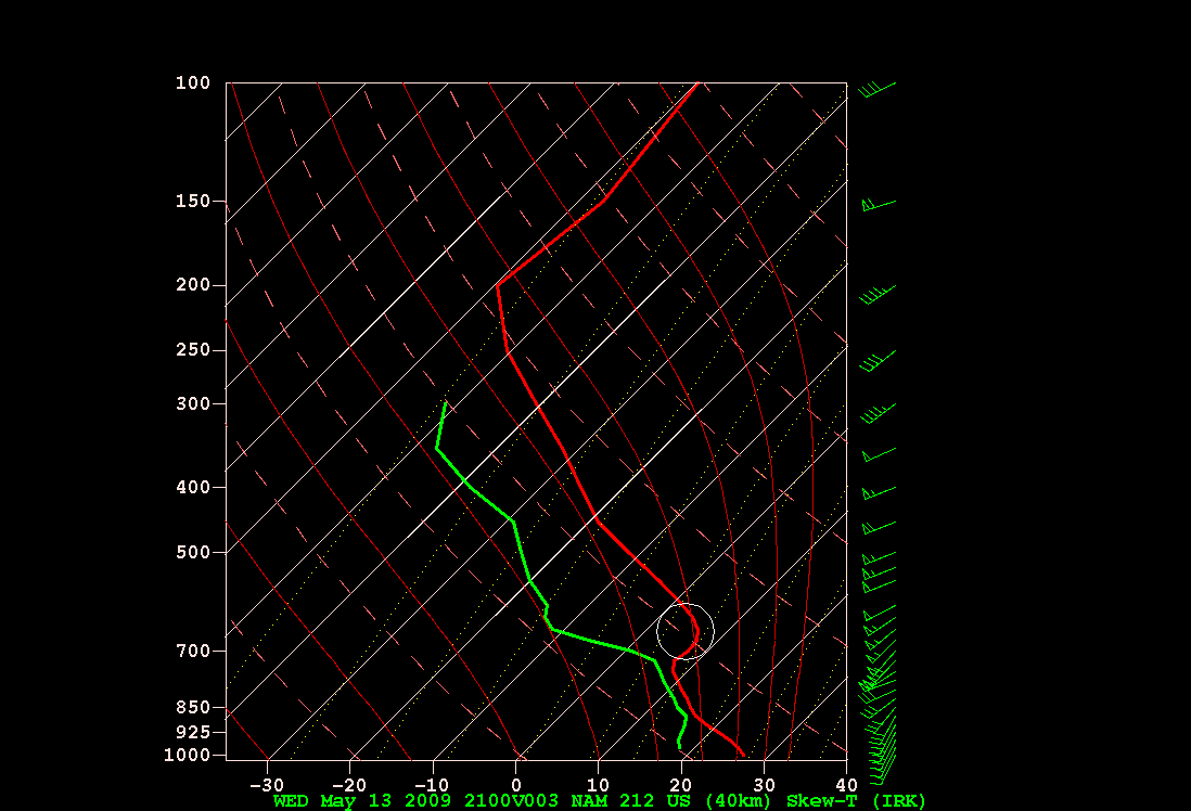
The 21Z surface-based CAPE and CIN map shows Kirksville, MO to be between an area of SBCAPE ranging from 2000 J/KG to 3000 J/KG which is fairly large. However, there was also SBCIN over Kirksville in the range of 25 J/KG to 100 J/KG which qualifies as moderate to large. Since CIN is a measure of the strength of a cap, this would correspond with a capping inversion which can be seen around 700-mb on NAM’s 3-hr forecast sounding, valid at 21Z, from Kirksville.
|
|
With a capping inversion and therefore SBCIN in place, there would need to be something to help air parcels break through it in order to reach their LFC so storms could develop. The cold front would provide low-level convergence, in association with lift from moisture convergence along and ahead of the front, and with the upper-level divergence provided by the approaching shortwave trough and its associated vorticity, this combination is what likely helped give air parcels lift to reach their LFC. As soon as they reached their LFC, they had plenty of CAPE to accelerate upwards and create strong updrafts. Once that happened, the stage was set for the thunderstorms to quickly develop.
By late afternoon, intense supercells had developed just ahead of the cold front and were making their way towards Kirksville, as can be seen on the 2155Z regional reflectivity image. Storms extended from the Kansas/Missouri border and then northwest towards the northern portion of the state all the way to the Iowa border.
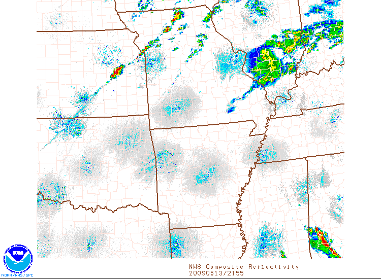
The 2155Z regional radar reflectivity shows supercells developing ahead of the cold front and extending from the Kansas/Missouri border and northwest towards the Iowa/Missouri border. (Courtesy of the National Weather Service and the National Climatic Data Center.)
Just under an hour later, the storms arrived in the Kirksville area. According to the 2248Z radar reflectivity image from Kansas City, Kirksville was in the center of the powerful supercell that spawned the tornado that tore through the city. The supercell did not have the classic appearance with a hook echo; however, it still was an intense, rotating storm.
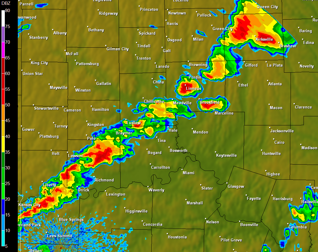
The 2248Z radar reflectivity image from Kansas City (KAEX) shows the supercell over Kirksville. (Courtesy of the National Weather Service and the National Climatic Data Center.)
The 2248Z storm-relative winds image from Kansas City indicated two areas of rotation near Kirksville. On the storm-relative reflectivity image, the red is moving away from the radar site while the green is moving towards it. When the inbound and outbound velocities are close together, that often is an indication of rotation within the storm. A Tornado Vortex Signature is then detected if the combined speed of the inbound and outbound velocities, otherwise known as gate-to-gate shear, is significant enough depending on how far the storm is from the radar site.
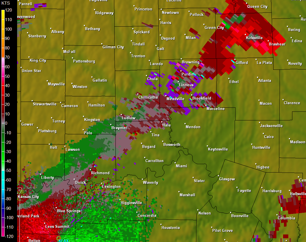
The 2248Z storm-relative winds image from Kansas City (KAEX) shows an area of rotation south of Kirksville, as well as a stronger area of rotation northwest of the city. (Courtesy of the National Weather Service and the National Climatic Data Center.)
According to the storm-relative winds reflectivity, the rotation just south of Kirksville was fairly weak and a TVS was not detected. However, to the northwest of Kirksville, there was a significant area of rotation with gate-to-gate shear of approximately 85 knots. A TVS would be detected with this large amount of shear, despite the area being a considerable distance from the radar site in Kansas City. The storm summary from the National Weather Service in Kansas City reports that at 2248Z, there was a tornado on the ground to the northwest of Kirksville. This would correspond with the strong area of rotation just northwest of the city. It also reports that at 2250Z, a funnel cloud was spotted to the south of Kirksville which likely is associated with the weaker area of rotation detected on the storm-relative winds reflectivity.
As can be seen by this report, the weather pattern on May 13th, 2009 was favorable for severe weather. With a potent low pressure system and its cold front pushing into unstable air over Missouri, along with other synoptic features and smaller mesoscale details falling into place, the ingredients were there for an outbreak of severe weather and tornadoes, including the tornado that hit Kirksville.
