


The Big Picture
The early morning hours of May 13th, 2009 began with a cold front draped across parts of Iowa and Nebraska. According to HPC’s 12Z surface analysis, this cold front was associated with a potent low pressure system located in southeastern Manitoba. In addition to the cold front, an occluded front extended from the surface low southward into Minnesota. A separate warm front also stretched across the northern portion of Missouri.
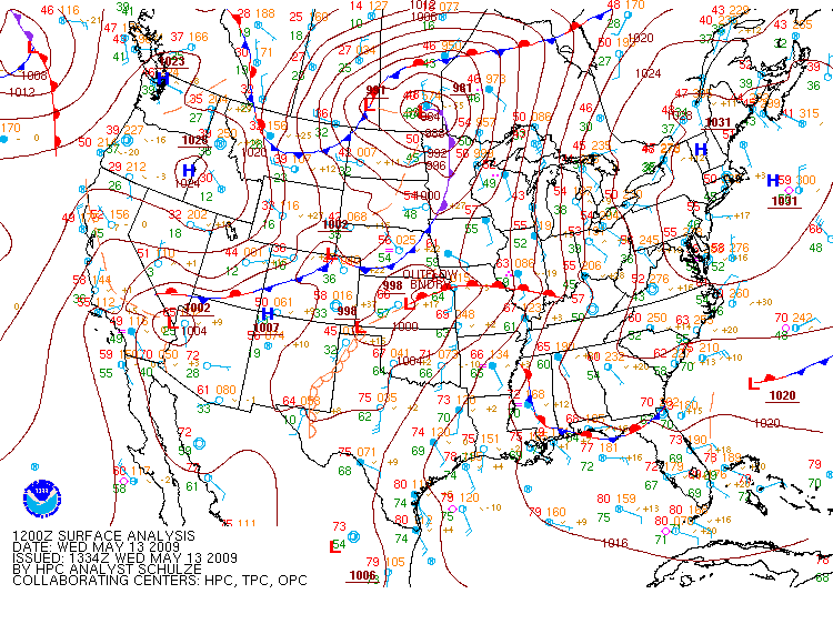
The 12Z surface analysis shows a strong low pressure system and its associated fronts as well as a warm front over Missouri. (Courtesy of the Hydrometeorological Prediction Center.)
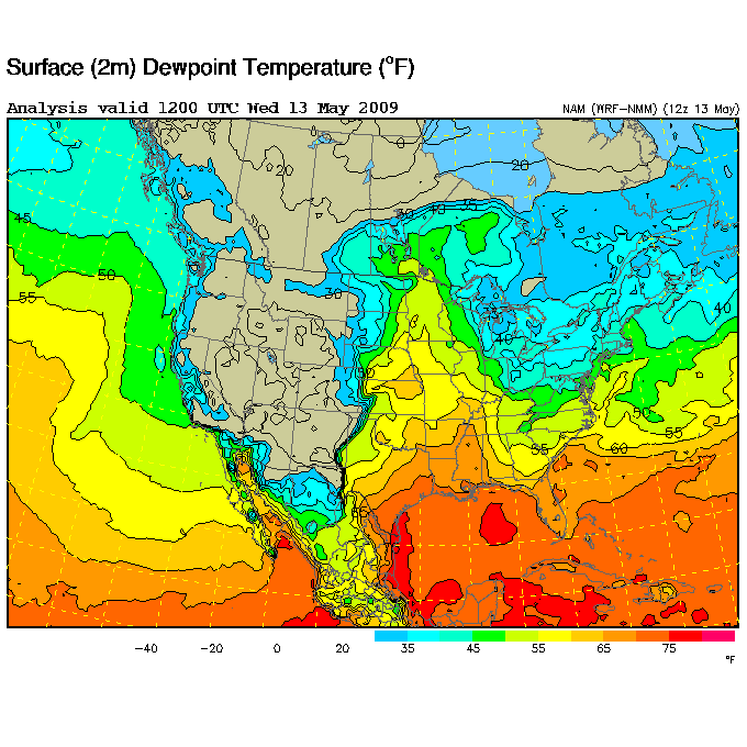
This warm front would begin to track northward as winds out of the south pushed it along. Weather stations from the Southern Mississippi Valley, stretching to the Southern Plains and to the Mid-Mississippi Valley, reported southerly winds according to the 12Z surface analysis. As the warm front drifted to the north, the southerly winds would also draw in warm, moist air over Missouri.
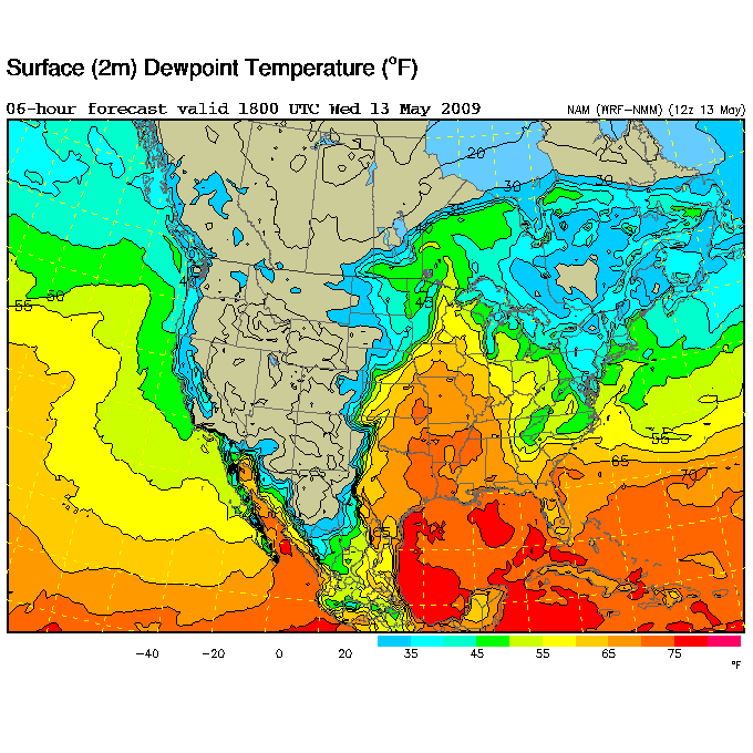
The effect of southerly winds pulling in moisture over Missouri can be seen on NAM’s 6-hr dew point forecast valid at 18Z. At 12Z, the dew point temperatures across the northern portion of the state, according to NAM’s surface dew point analysis, ranged from 55°F to 60°F. However, NAM’s 6-hr dew point forecast indicates that by 18Z, dew points over northern Missouri were predicted to increase to a range of 65°F to 70°F. With warm, moist air building ahead of the approaching cold front, the atmosphere would grow increasingly unstable throughout the day as dew points began to climb.
|
|
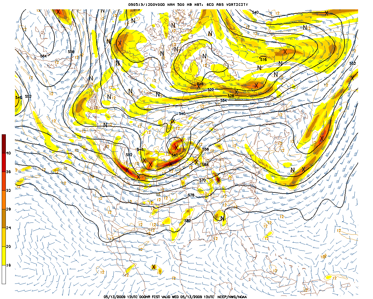
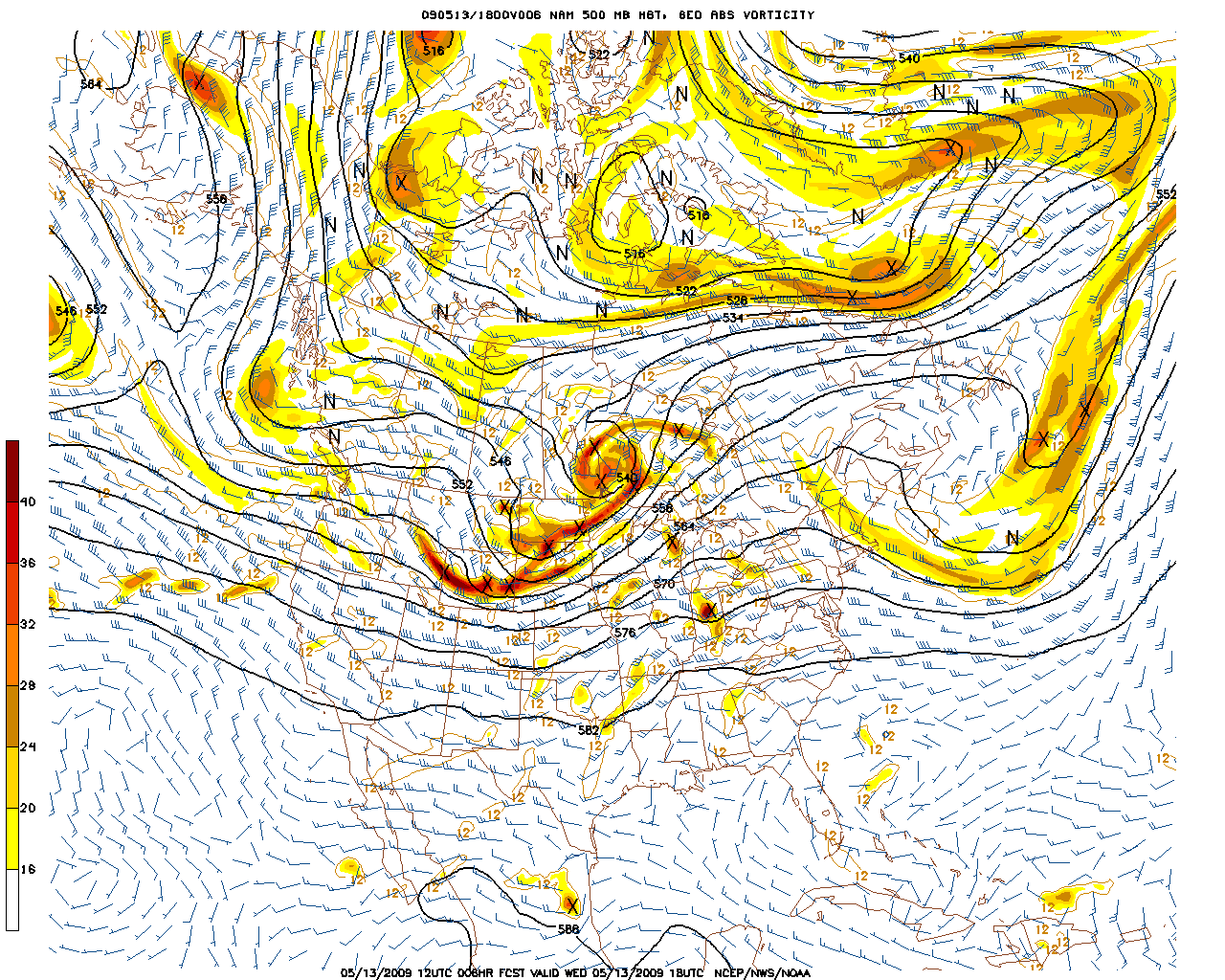
The cause for the surface low pressure system and its associated cold front was a potent shortwave trough at 500-mb, as was evident on NAM’s 12Z 500-mb model analysis. Multiple vorticity maximums were traveling along the trough which would cause strong areas of divergence and provide a lifting mechanism to help trigger thunderstorm development. Also, residing directly over the surface low was a closed low at 500-mb and associated vort max near the center of circulation. Since the surface low was located underneath the 500-mb closed low, the low pressure system was vertically stacked. By 18Z, according to NAM’s 500-mb 6-hr forecast, the closed low was predicted to open. The vort maxes also increased in number and took on a stream-like appearance as strong counter-clockwise winds at 500-mb wrapped them around the low. I think it’s interesting how the stream of vorticity has a cyclonic look as it wraps around the center of the low. Although the low was forecasted to open, it hadn’t made much progress in movement and still remained above the surface low.
|
|
NAM’s 12Z 500-mb model analysis (left) shows a potent shortwave trough and associated vort maxes, as well as a closed low. NAM’s 500-mb 6-hr forecast, valid at 18Z, (right) shows the previously closed low now open as well as an increased number of vort maxes. (Courtesy of the National Centers for Environmental Prediction.)
With the low pressure system vertically stacked and having reached its maximum intensity, the Mean Sea Level Pressure of the low was close to being at its lowest. NAM’s 12Z analysis of MSLP shows a tight packing of isobars around the surface low with a pressure of 984 mb around the very center of the low. That low of a central pressure indicates just how intense the system had become.
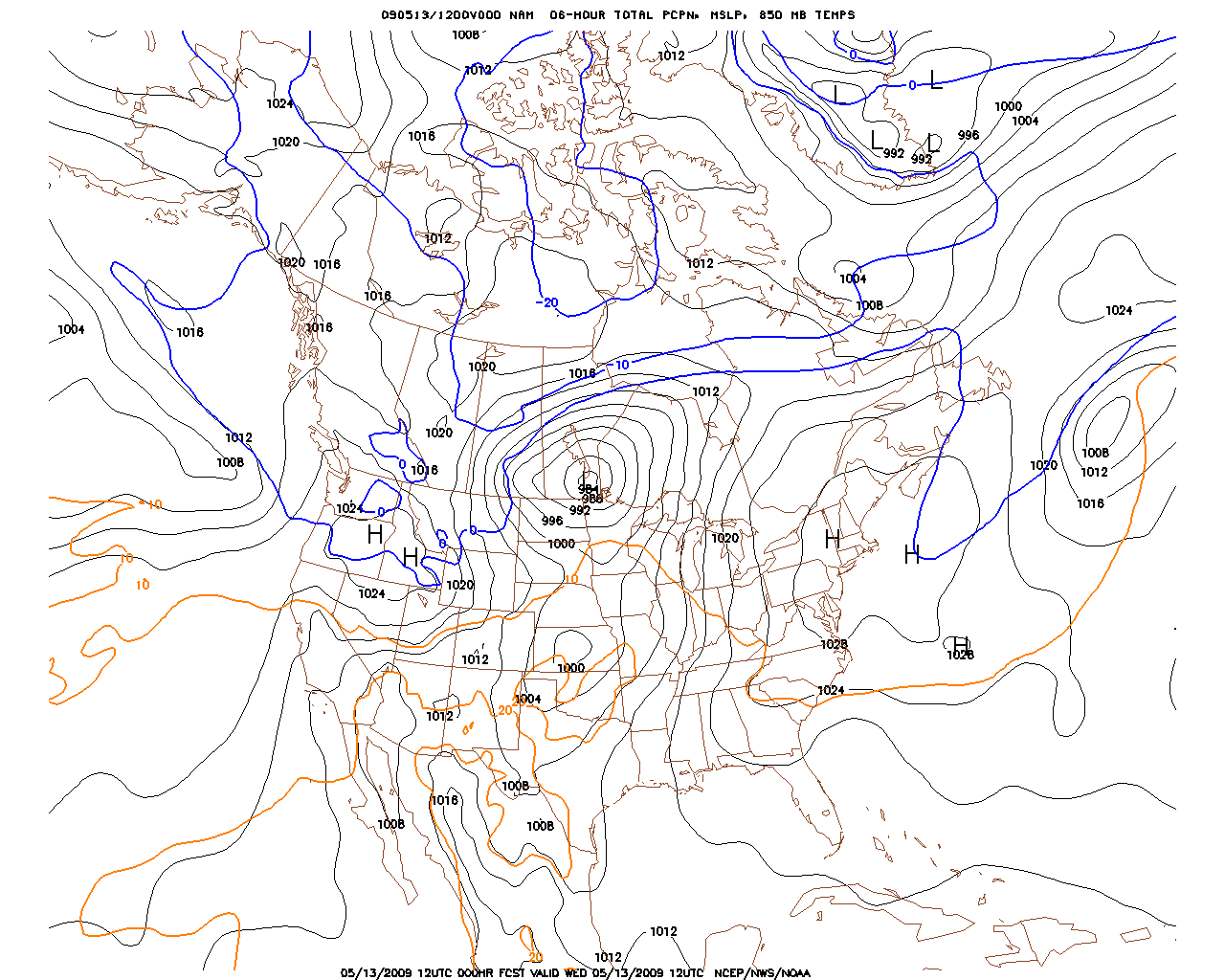
NAM’s 12Z analysis of MSLP shows isobars tightly packed around the center of the low pressure system with a central pressure of 984 mb. (Courtesy of the National Centers for Environmental Prediction.)
By 21Z, the MSLP around the center of the surface low had dropped 1 mb to 983 mb according to HPC’s 21Z surface analysis. The warm front that was previously stretched across Missouri pushed northward into Iowa and Illinois to join with the approaching cold front. Where the two fronts intersected was another low. The cold front was now beginning to enter the northwestern corner of Missouri.
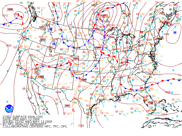
The 21Z surface analysis shows the cold front entering Missouri and having joined with the warm front. (Courtesy of the Hydrometeorological Prediction Center.)
As the cold front pushed ahead into warm, moist, unstable air with cooler and very dry air trailing behind it, it looked as if the ingredients were coming together for a severe weather outbreak as the two contrasting air masses clashed. On the synoptic-scale, conditions were favorable for severe weather. Let’s take a look at the smaller mesoscale details that contributed to the severe weather outbreak.
<< Back | Top | Next >>
