


Introduction
Much of the Central and Northern Plains experienced a significant severe weather outbreak on the evening of June 17th, 2009. Nebraska was one of the hardest hit states with numerous reports of damaging winds, large hail, and multiple tornadoes (see storm reports).
Around 8:59 pm CDT, a powerful supercell produced one of the reported tornadoes just west of the city of Aurora, Nebraska. At its strongest, the tornado was rated an EF-2 and lasted for approximately 18 minutes before dissipating (see tornado track).
Prior to this severe weather event, the Storm Prediction Center issued Tornado Watch #440 at 12:55 pm CDT. This tornado watch was in effect until 9:00 pm CDT for portions of southwest Iowa, northeast Kansas, northwest Missouri, and south-central and southeast Nebraska. The tornado watch included Hamilton County, which is where the city of Aurora is located in south-central Nebraska. Within this watch box, there was a moderate risk for supercells to go on to spawn tornadoes.
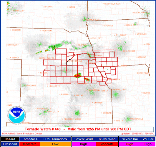
The counties within the watch box for Tornado Watch #440, valid from 12:55 pm CDT to 9:00 pm CDT on June 17th, 2009. Outlined in black is Hamilton County, which is where the city of Aurora is located. (Courtesy of the Storm Prediction Center.)
The set-up that day was favorable for the development of tornadic supercells. In the early morning, SPC’s 13Z Convective Outlook (see image) had the same area under a moderate risk of severe weather. In this report, I will explain the synoptic-scale and mesoscale details that led to this severe weather outbreak and the Aurora, Nebraska tornado, in particular. First, let’s take a look at the synoptic-scale features that served as a background for the day’s severe weather events.
<< Back | Top | Next >>
