


The Big Picture
As I previously mentioned, the Storm Prediction Center had much of Nebraska in a moderate risk of severe weather by the early morning hours of June 17th, 2009, including the city of Aurora. Conditions throughout the day were predicted to become favorable for the development of severe storms.
The trigger for severe weather that day was a surface low and warm front, as can be seen on the 18Z surface analysis. The surface low was located in northwestern Kansas and was situated along a warm front that curved northward across south-central Nebraska. South of this warm front was a hot and moist air mass. Temperatures had already climbed into the upper 80°F’s to low 90°F’s while dew points ranged from the low 60°F’s to the mid 70°F’s, according to surface observations at 18Z. Talk about uncomfortable and sticky!
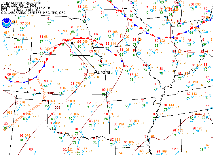
The 18Z surface analysis on June 17th, 2009 shows a surface low in northwestern Kansas and a warm front through south-central Nebraska. South of the warm front is a hot and moist air mass. (Courtesy of the Hydrometeorological Prediction Center.)
Observations on the 18Z surface analysis also reported southerly to southeasterly winds over much of the Central and Southern Plains. With winds as strong as 10 to 25 knots in some locations, the warm, moist air to the south would continue to be pulled into south-central Nebraska.
However, behind the surface low and warm front, winds across northern and western Nebraska were backed. This means that the winds changed direction in a counter-clockwise sense due to the surface low. The backing winds would help to increase low-level wind shear, which is necessary for the development of tornadoes.
To aid the southerly surface winds with drawing in warm, moist air over south-central Nebraska, warm-air advection was also taking place at 850-mb. According to NAM’s 18Z 850-mb analysis, winds were south to southwest at around 20 knots over much of the Central and Southern Plains. By 00Z, southerly winds at 850-mb were predicted to persist over the region, according to NAM’s 6-hr 850-mb forecast (valid at 00Z). Their speed was also expected to increase to 20 to 35 knots. This would help continue to pull in warm, moist air from the Gulf of Mexico over the Central Plains.
|
|
NAM's 18Z 850-mb analysis from June 17th, 2009 (left) shows south to southwest winds over the Southern and Central Plains at around 20 knots. NAM's 6-hr 850-mb forecast, valid at 00Z on June 18th, 2009, (right) shows the winds increasing to 20 to 30 knots. (Courtesy of the National Centers for Environmental Prediction.)
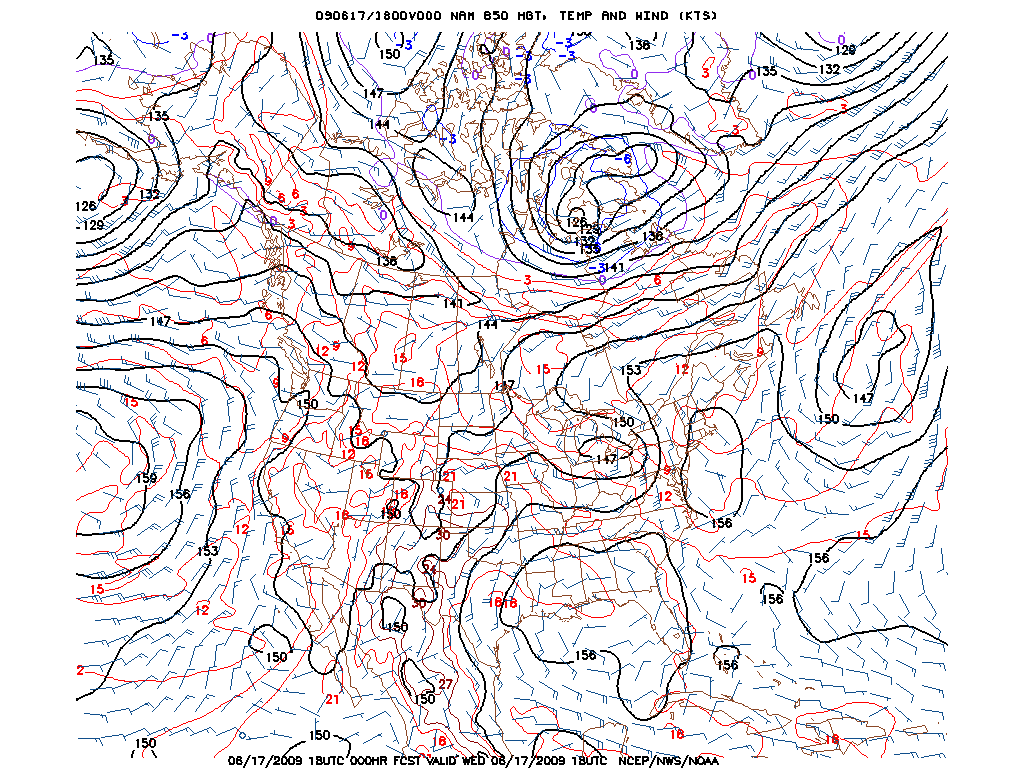
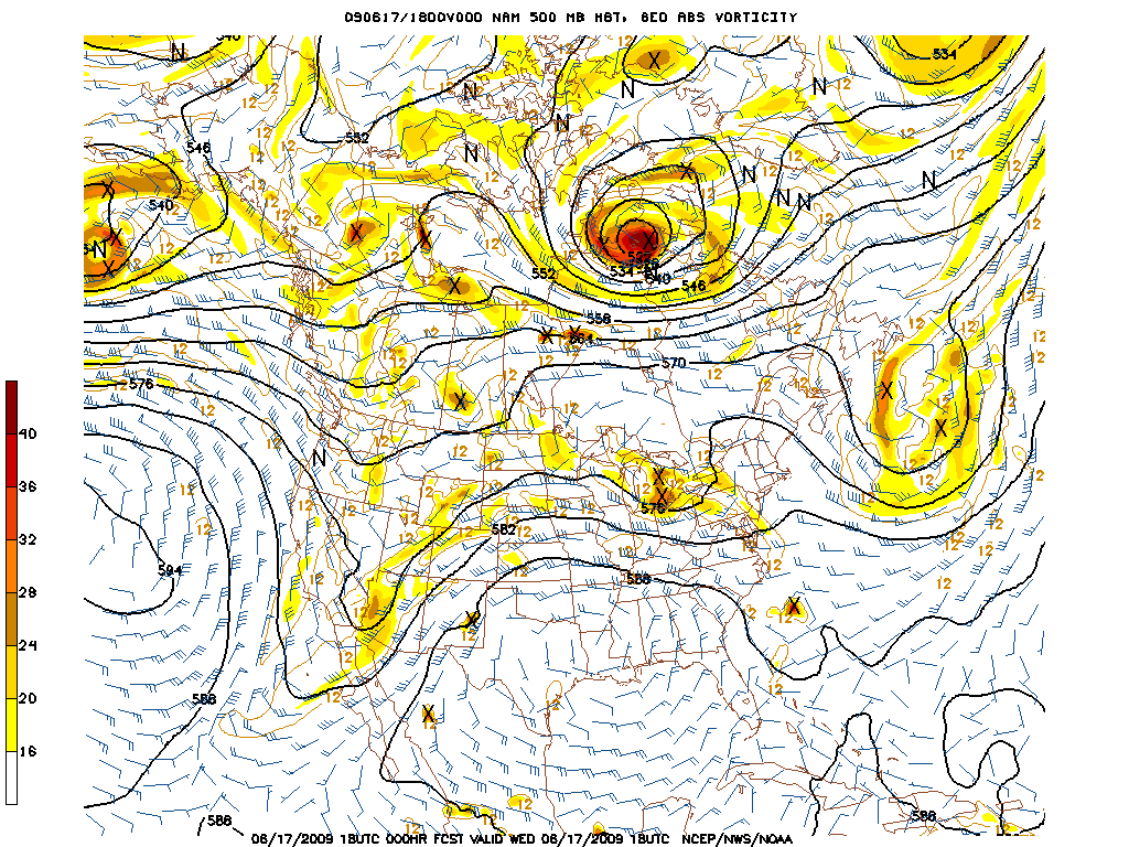
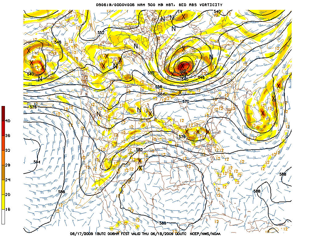
The warm air mass over the southern states corresponded with an area of high 500-mb heights, according to NAM’s 18Z 500-mb analysis. Also at 500-mb, there was a small area of weak vorticity associated with the surface low in northwestern Kansas, as well as another area of weak vorticity in northwestern Nebraska. A trough was approaching from the southwestern states, and ahead of it was a stream of moderate southwesterly winds over the Southern Rockies and the Central Plains. The 500-mb winds were blowing at 40 knots over south-central Nebraska.
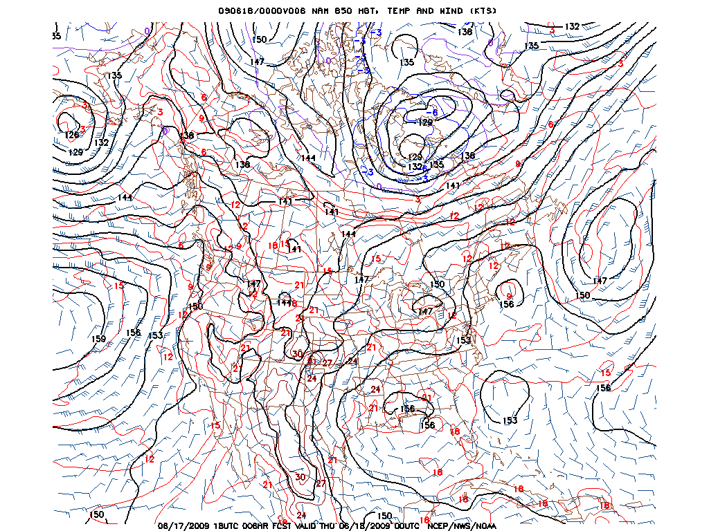
By 00Z, the 500-mb winds over south-central Nebraska were expected to increase to 45 knots, as was predicted by NAM’s 6-hr 500-mb forecast (valid at 00Z). The small area of vorticity that had previously been located in northwestern Kansas, according to the 18Z analysis, had decreased in size and moved slightly to the east. Coming up behind the small area of vorticity was a newly developed compact vort max located in southwestern Kansas. Also, the area of vorticity in northwestern Nebraska was predicted to strengthen slightly and spread a little farther east.
|
|
NAM's 18Z 500-mb analysis from June 17th, 2009 (left) shows a stream of moderate winds over the Southern Rockies and the Central Plains ahead of an approaching trough, as well as multiple areas of weak vorticity in the Central Plains. NAM's 6-hr 500-mb forecast, valid at 00Z on June 18th, 2009, (right) predicted winds over south-central Nebraska to increase and a vort max to develop in northwestern Kansas, along with a strengthening area of vorticity in northwestern Nebraska. (Courtesy of the National Centers for Environmental Prediction.)
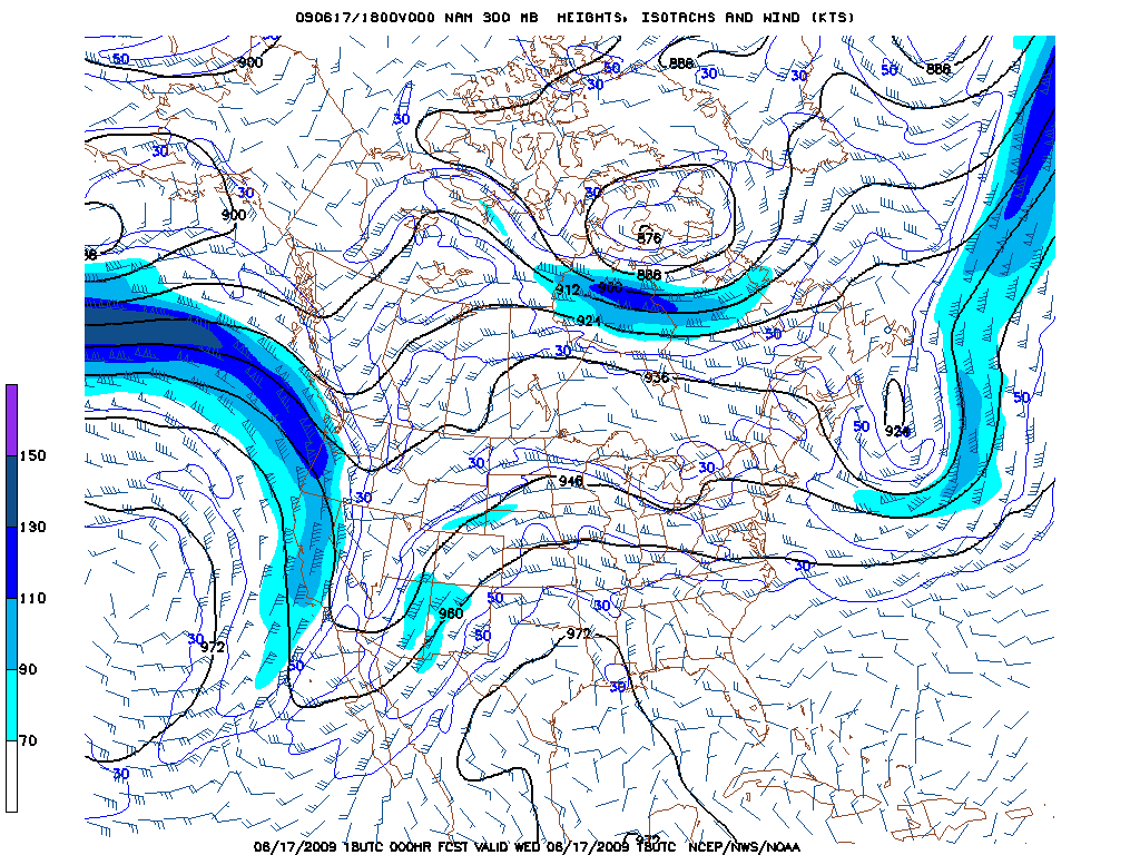
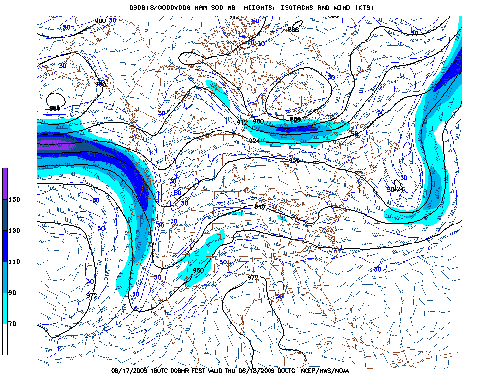
Meanwhile, at 300-mb, the upper-level winds over Nebraska were also moderate, according to NAM’s 18Z 300-mb analysis. The west-southwesterly 300-mb winds above Nebraska ranged from 40 to 55 knots over the southern portion of the state, with a pocket of 75 knots over the northwestern corner. According to NAM’s 6-hr 300-mb forecast (valid at 00Z), the upper-level winds over Nebraska were predicted to increase to 60 knots over the southern half of the state, with an area of winds 70 to 75 knots spreading into the southwestern corner.
|
|
NAM's 18Z 300-mb analysis from June 17th, 2009 (left) shows moderate upper-level winds over Nebraska. NAM's 6-hr 300-mb forecast, valid at 00Z on June 18th, 2009, (right) shows the upper-level winds over Nebraska increasing, along with a pocket of strong winds spreading into the southwestern corner of the state. It is probable that the jet stream, which would be located at 250-mb, would have corresponded with the stream of moderate to strong winds at 300-mb, meaning that the jet stream would be over Nebraska. (Courtesy of the National Centers for Environmental Prediction.)
On the synoptic-scale, the surface and upper-level features were falling into place for an outbreak of severe weather. Discrete supercells had developed over Nebraska by 7:00 pm CDT, as can be seen on the regional 00Z composite reflectivity. This is important because in order for discrete supercells to erupt, a fairly strong capping inversion would need to have been present that day. With a cap in place, this would make the atmosphere favorable for explosive convection once the cap eroded. Otherwise, chances are that a squall line would have formed rather than discrete supercells had there not been a capping inversion. Of course, unless air parcels are able to break through the cap to reach their LFC, there would be no storms. To erode the cap, dynamic lifting was needed.
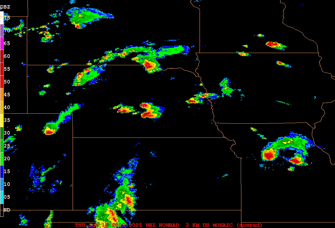
The regional composite reflectivity from 00Z on June 18th, 2009 shows discrete supercells over Nebraska. (Courtesy of the National Weather Service.)
Dynamic lifting would be provided by low-level convergence along the warm front, along with some upper-level divergence at 500-mb, and the heating of the day. The dynamic lifting would be modest but sufficient to erode the cap. This would set the stage for explosive convection and discrete supercell development, as was indicated by the radar.
Next, let’s take a look at the mesoscale details that contributed to the development of the supercells and the severe weather outbreak.
<< Back | Top | Next >>
