


El Niño and the Subtropical Jet
The subtropical jet stream is a belt of strong upper-level winds that is located near latitude 30°. The strong winds associated with the subtropical jet begin at 400-mb and reach a maximum speed at around 200-mb to 150-mb. During the summer months, the subtropical jet tends to be relatively weak due to a reversal in the typical north-south temperature gradients, where it is actually warmer at latitude 30° than across the equatorial Pacific. However, this changes during the winter months when the subtropical jet is at its strongest, which causes it to potentially have more of an impact on mid-latitude weather.
The 200-mb Vector Wind Climatology shows that during the winter months under normal, non-El Niño conditions, the strongest area of the subtropical jet lies over the western Pacific, with a pocket of maximum wind speeds located off the southern coast of Japan. It extends eastward, just past the International Date Line, before it begins to lose some of its identity. As the subtropical jet reaches the southern and eastern half of the United States, it once again becomes more pronounced, although not as strong as it is in the western Pacific.

The 200-mb Vector Wind Climatology, from November 15th through February 28th, and between the years of 1968 through 1996, shows the typical pattern of the subtropical jet during the cold season under non-El Niño conditions. (Courtesy of the Earth System Research Laboratory.)
When an El Niño takes place in the Pacific, the subtropical jet changes considerably, as evident on the 200-mb Vector Wind Composite Mean from the height of the 1982-1983 El Niño. The strong upper-level winds associated with the subtropical jet strengthened across the western Pacific and stretched farther east, well past the International Date Line. Instead of losing some of its identity, like under non-El Niño conditions, the jet remained pronounced as it spread eastward towards North America. From there, it took a more southerly path across Mexico through the Gulf Coast States.
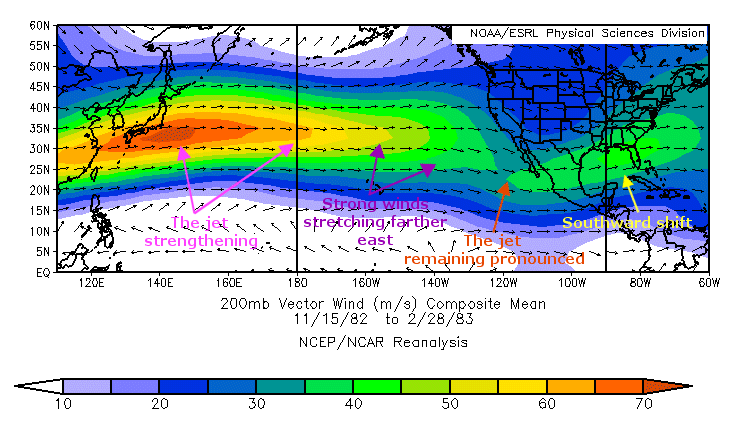
The 200-mb Vector Wind Composite Mean, from November 15th, 1982 through February 28th, 1983, shows the subtropical jet strengthening over the Pacific and shifting southward over Mexico and the Gulf Coast States. (Courtesy of the Earth System Research Laboratory.)
As can be seen by the comparison of the two images above, there is a definite change in the subtropical jet when an El Niño takes place. These changes in the subtropical jet are due to enhanced baroclinicity across the Pacific Ocean. The 400-mb Air Temperature Composite Anomaly shows an area of above normal air temperatures over the Pacific that are associated with the warm surface waters of the 1982-1983 El Niño.
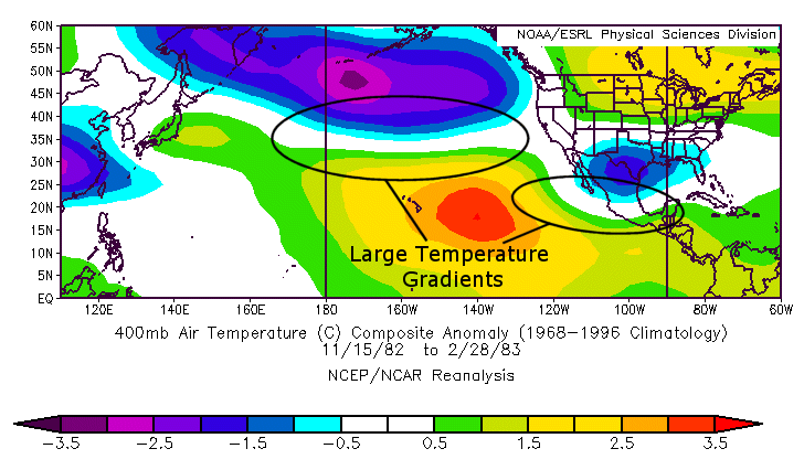
The 400-mb Air Temperature Composite Anomaly, from November 15th, 1982 through February 28th, 1983, shows large temperature gradients over the Pacific due to above normal air temperatures associated with the warm surface waters of El Niño. (Courtesy of the Earth System Research Laboratory.)
With cooler, below normal air temperatures to the north, this contrast caused a large temperature gradient over the Pacific, which served to strengthen the subtropical jet and stretch it farther eastward. Another area of large temperature gradients extended through the eastern Pacific, into Mexico, and across the Gulf of Mexico, which helped the subtropical jet to remain pronounced and strengthen over Mexico into the Gulf Coast States.
Seasonal Impacts of El Niño
During the 1982-1983 El Niño, much of the Gulf Coast States saw above normal precipitation throughout the cold season. Precipitation anomalies ranged from 1 to 2.5 mm/day over portions of the southeastern United States. This abnormally wet weather pattern was connected to the strong subtropical jet over the region. To further explain how the jet played a role in producing the unusually wet seasonal weather pattern across the Gulf Coast, let’s take a look at its position on December 12th, 1982.
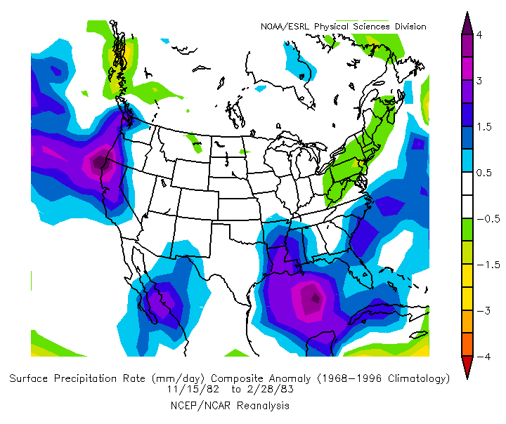
The Surface Precipitation Rate Composite Anomaly, from November 15th, 1982 through February 28th, 1983, shows that much of the Gulf Coast States received above normal precipitation during the 1982-1983 cold season. (Courtesy of the Earth System Research Laboratory.)
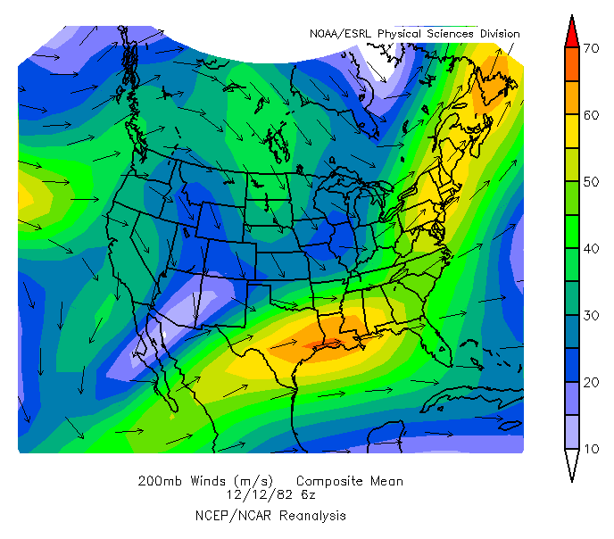
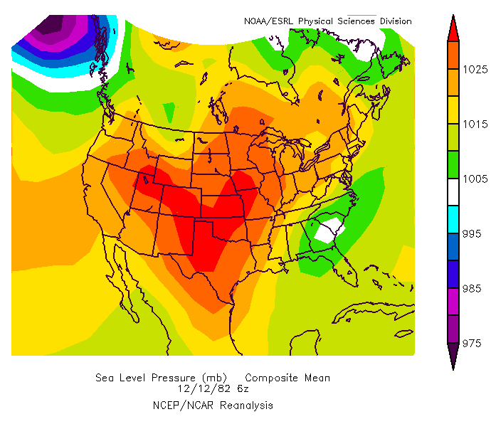
The 200-mb Winds Composite Mean shows the potent subtropical jet over the southeastern United States. Along with the jet was a jet streak, which was located across a portion of the Gulf Coast States. At the same time, the center of a low pressure system was positioned above eastern Georgia and southern South Carolina, as can be seen on the Sea Level Pressure Composite Mean.
More importantly, the center of low pressure was located near the left-exit region of the jet streak within the subtropical jet. The divergence associated with left-exit region would help to intensify the low. Moisture from the Pacific would also be pulled in by the subtropical jet to enhance precipitation within the low pressure system.
|
|
The 200-mb Winds Composite Mean, from December 12th, 1982, (left) shows the strong subtropical jet across the southeastern United States, with a jet streak over portions of the Gulf Coast States. The Sea Level Pressure Composite Mean, from December 12th, 1982, (right) shows a center of low pressure to be in the area of the left-exit region of the jet streak. (Courtesy of the Earth System Research Laboratory.)
With the subtropical jet positioned over the southeastern United States during the course of the 1982-1983 cold season, repeated cyclogenesis would take place in this area. This is what led to the abnormally wet weather pattern across much of the Gulf Coast States, and how the subtropical jet had an impact on the region's seasonal weather.
Surprisingly, air temperatures during the 1982-1983 cold season for the Gulf Coast States were near normal to slightly above normal. The Surface Air Temperature Composite Anomaly shows a lack of cool anomalies over the region that would be associated with below average temperatures. With an unusually wet weather pattern in place, it would be expected that temperatures might tend to be cooler than normal, especially since temperatures along the Gulf Coast are typically below average during an El Niño.
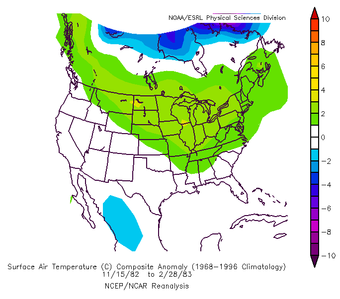
The Surface Air Temperature Composite Anomaly, from November 15th, 1982 through February 28th, 1983, shows temperatures across the Gulf Coast to be near normal to slightly above normal during the 1982-1983 cold season. (Courtesy of the Earth System Research Laboratory.)
