


Introduction
During the cold season of 1982 to 1983, a strong El Niño was occurring in the Pacific Ocean. When an El Niño occurs, the surface waters of the eastern and central equatorial Pacific become unusually warm, as can be seen on the animation below from the 1982-1983 El Niño. Notice the growing area of above normal sea-surface temperature anomalies spreading across the eastern and central equatorial Pacific that are associated with the developing and intensifying El Niño.
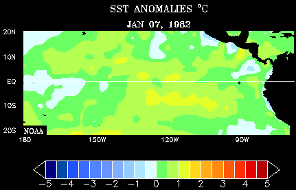
Sea-surface temperature anomalies, from January of 1982 to December of 1983, show the warming of the central and eastern equatorial Pacific during the 1982-1983 El Niño. (Courtesy of the Earth System Research Laboratory.)
Between the months of March through June is typically when an El Niño begins to develop. Prior to its development, the trade winds that blow along the equator begin to relax, which signals the onset of an El Niño. An El Niño reaches its peak intensity between December through April of the next year, and then usually begins to weaken in the months from May through July.
When an El Niño occurs, it can impact weather patterns globally. While no one storm can be blamed on El Niño, there are recurrent weather patterns that are associated with an El Niño episode. In the United States, these weather patterns are connected to changes in the subtropical jet stream that occur when there is an ongoing El Niño.
In the next section, I will explain the changes in the subtropical jet stream during the 1982-1983 El Niño episode and focus on how these changes impacted the seasonal weather in the southeastern portion of the United States.
