

The Big Picture
On March 1st, 2010, when I created my high temperature forecast for March 2nd, 2010 that would bust, a low pressure system was located just off the Texas coast. This low pressure system was expected to track to the east-northeast during the next day (see forecast loop; Courtesy of the Hydrometeorological Prediction Center) with the area of precipitation associated with the system staying south of Little Rock.
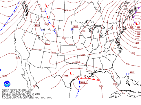
The 18Z surface analysis from March 1st, 2010 shows a low pressure system located off the coast of Texas. (Courtesy of the Hydrometeorological Prediction Center.)
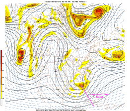
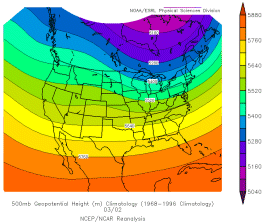
The GFS 500-mb forecast for 18Z on March 2nd, 2010 showed a negatively tilted trough associated with the surface low pressure system moving eastward across Florida. Heights at 500-mb were also well below what is typical for Little Rock during March, indicating a departure from climatology.
|
|
The GFS 24-hr 500-mb forecast (left), valid at 18Z on March 2nd, 2010, shows a negatively tilted trough associated with the surface low pressure system. (Courtesy of the National Centers for Environmental Prediction.) The climatology for 500-mb heights for March 2nd (right), spanning from 1968 to 1996, shows that 500-mb heights on March 2nd, 2010 were a departure from climatology. (Courtesy of Earth System Research Laboratory.)
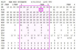
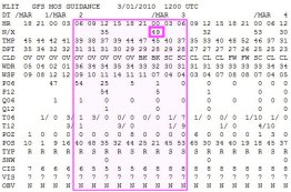
With a low pressure system sliding off to the south and a departure from climatology that was causing MOS to struggle, forecasting the high temperature was going to be tricky. NAM MOS was forecasting a high of 52°F for March 2nd, 2010 and GFS MOS was forecasting a high of 49°F, so there was some disagreement. MOS also tends to run too warm north of a low pressure system where precipitation often falls, however, I was uncertain if this would affect Little Rock since the precipitation was expected to stay south.
|
|
NAM MOS (left) was forecasting a high of 52°F for Little Rock on March 2nd, 2010 while GFS MOS (right) was forecasting a high of 49°F. (Courtesy of the National Weather Service.)
With MOS disagreeing, I turned to the SREF Plume to see how the ensemble members compared with MOS. As it would turn out, the ensemble members were also disagreeing with a large spread ranging from 42°F to 50°F for a predicted high. The average mean temperature between the ensembles was 47°F, which was below what MOS was forecasting.
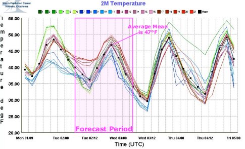
The SREF Plume for the forecast period, ranging from 06Z March 2nd, 2010 to 06Z March 3rd, 2010, shows a large spread between the ensemble members with an average mean of 47°F. (Courtesy of the Storm Prediction Center.)
The issue with the high temperature was going to be clouds from the low pressure system. If clouds persisted throughout the day, this would suppress temperatures. The 30-hr cloud forecast, valid at 18Z on March 2nd, 2010, showed a contrasting forecast of clouds between the models. The WRF predicted clear skies in Little Rock while the AVN indicated a thick, low overcast across Arkansas.
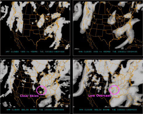
The 30-hr WRF/AVN cloud forecast, valid at 18Z on March 2nd, 2010, shows that the WRF model predicted clear skies over Little Rock while the AVN model predicted a thick, low overcast. The cloud forecast loop, ranging from 06Z March 2nd, 2010 to 06Z March 3rd, 2010, gives a better idea of how the WRF predicted clearing skies while the AVN had clouds sticking around throughout the forecast period. (Courtesy of Penn State University.)
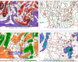
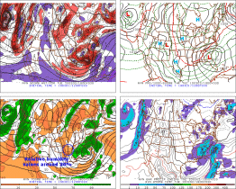
My next step was to take a look at the WRF and AVN 30-hr forecast progs, valid at 18Z on March 2nd, 2010, to check the predicted 700-mb relative humidity. There was finally some agreement with both models indicating relative humidity values around 30% over Little Rock. The drier values would tend to favor clearing skies with the area of higher relative humidity associated with clouds well to the east.
|
|
The WRF and AVN 30-hr forecast progs, valid at 18Z on March 2nd, 2010, shows both models predicting 700-mb relative humidity values to be around 30% over Little Rock. (Courtesy of Penn State University.)
The 18Z visible satellite image (see image; Courtesy of University Corporation for Atmospheric Research) from March 1st, 2010 showed the low pressure system with clearing behind it. I figured that the low would be well away from Arkansas by early afternoon the next day so I decided to go with the majority of the models forecasting clearing skies. Precipitation was not expected and temperatures were already below normal so I was hesitant to undercut MOS, especially if skies were to clear since this would lead to warmer temperatures. In the end, I went in between MOS and forecasted a high of 50°F.
 << Back | Top | Next >>


